Abstract
In order to improve the regional planning ability of land acquisition for water conservancy and hydropower construction, a technology of land acquisition area mapping for water conservancy and hydropower construction based on UAV aerial survey is proposed. This technology uses UAV aerial survey remote sensing detection technology to realize remote sensing image monitoring of land acquisition planning for water conservancy and hydropower construction, so as to improve the accuracy and efficiency of regional planning. This technology mainly extracts information such as edge contours, key feature points, and texture pixels from remote sensing images for land acquisition mapping in water conservancy and hydropower construction. The line element feature distribution points monitored by drones scatter remote sensing images as the data source, and linear object segmentation detection processing method is used for analysis. Based on the clustering characteristics of geometric attributes such as dams, water body characteristics, fence facilities, and power generation equipment in water conservancy and hydropower construction, a regional clustering analysis model for land acquisition mapping in water conservancy and hydropower construction is established using the diversity clustering method of different terrain and geomorphic feature distribution patterns. By utilizing the regional distribution fusion of concave and convex terrain, detecting and quantitatively estimating the spatial resolution and complexity of land acquisition for water conservancy and hydropower construction, optimizing the mapping of land acquisition areas for water conservancy and hydropower construction, and providing data basis for land acquisition protection management in water conservancy and hydropower construction planning. The experiment shows that this method has good output resolution, land planning ability, and classification performance for different types of land acquisition for water conservancy and hydropower construction, and has broad prospects for promotion and application in practical applications.
Highlights
- Utilizing drone aerial survey and remote sensing detection technology to achieve remote sensing image monitoring of land acquisition planning for water conservancy and hydropower construction has improved the accuracy and efficiency of regional planning.
- By extracting edge contours, key feature points, texture pixels, and other information from remote sensing images, combined with linear object segmentation detection processing methods, precise surveying and mapping of land acquisition for water conservancy and hydropower construction has been achieved.
- A regional clustering analysis model for land acquisition surveying and mapping in water conservancy and hydropower construction was established based on the clustering features of geometric attributes and the diversity clustering method of different terrain and geomorphic feature distribution patterns, providing reliable data basis for land acquisition protection management.
1. Introduction
With the strong support of the country, the number of water conservancy projects has mushroomed rapidly, the scale of projects has also been expanding, and the development of water conservancy is booming. However, at the same time, the construction of water conservancy projects has affected the natural ecological environment to a certain extent, and its negative impact on the natural environment has increasingly attracted people's attention. In the new era, we should use the concept of scientific development concept to promote the harmonious development of human and nature, correctly handle the relationship between water conservancy development and ecological environment, and achieve a win-win situation of water resources development and ecological environment protection. China's water conservancy projects include several major categories, such as hub projects, river projects and water diversion projects. Among them, as an important part of the main body of water conservancy projects, dykes can be said to be a relatively common engineering project. In the construction of reservoir, the dam has made great contributions to water storage and diversion with its important role of intercepting the river and blocking the water. It plays an important role in water conservancy projects and is widely used in various water conservancy projects. The structure of the dam mainly includes the main dam, auxiliary dam, gravity dam, power station, normal spillway, extraordinary spillway, new spillway and Lingzheng canal culvert pipe, etc., of which concrete dam is usually the most classical and commonly used dam type. In the reservoir construction, the dam plays an important role and has made a great contribution to the water storage and diversion. Therefore, the industry has always attached great importance to the quality control of the dam. The quality control of the dam not only ensures its own safety, but also affects other aspects of water conservancy facilities. As an important construction link in the construction of water conservancy projects, ensuring the normal and safe operation of the dam has been supported by a large number of human and material resources, and the research in all aspects is also being continuously promoted. During the construction, it is necessary to study the regional mapping method of land acquisition for water conservancy and hydropower construction to improve the planning ability of the construction position [1].
With the development of remote sensing mapping technology, the remote sensing and computer image feature analysis technology is used to establish the remote sensing image analysis model of land acquisition area for water conservancy and hydropower construction, so as to realize the optimization of land acquisition area for water conservancy and hydropower construction, and improve the utilization and comprehensive mapping management ability of land acquisition area for water conservancy and hydropower construction, The related research on regional surveying and mapping technology for land acquisition in water conservancy and hydropower construction has important research prospects in computer image and surveying and mapping[2]. Based on remote sensing monitoring of land acquisition area for water conservancy and hydropower construction, UAV technology is used for image acquisition, and digital image analysis and processing technology is used to improve the planning and utilization efficiency of land acquisition area for water conservancy and hydropower construction. The research on regional surveying and mapping of land acquisition for water conservancy and hydropower construction is based on the information analysis and image feature extraction of land surveying and mapping, and the cadastral surveying and mapping data analysis sample in the process of regional surveying and mapping of land acquisition for water conservancy and hydropower construction is constructed by the geographic environment spatial mapping technology, and the BIM analysis model is used to design the regional surveying and mapping database of land acquisition for water conservancy and hydropower construction [2].
Hierarchical classification is to classify the land according to different characteristic attributes. Through statistical analysis of sample points, the probability density function of each category is obtained, and then the land in the whole region is classified. This method is simple and easy to understand, with a wide range of applications. In situations where land attributes are complex and there are multiple categories, hierarchical classification can be used to achieve land mapping. The supervised classification method learns a classifier model through observation and statistical analysis of existing land sample data, and applies the model to land remote sensing data in the entire region to achieve land classification. This method is suitable for complex and diverse land types. Unsupervised classification method does not require prior knowledge and divides similar pixels into the same category through clustering analysis of remote sensing images. This method is simple and easy to implement, but requires strong professional skills and rich practical experience, and is suitable for situations with fewer land categories and unclear classification. Object oriented method is the use of physical features on land to achieve land classification. This method recognizes and classifies physical features on land, such as roads, buildings, water bodies, etc., and further classifies different objects to achieve land mapping. The rule based knowledge method identifies and divides land categories through professional knowledge and rules. This method is suitable for situations with rich professional knowledge and strong resolution of rules, but it requires continuous revision and updating of rules according to actual situations.
At present, the main airborne cloud data analysis methods, BIM mapping analysis methods and satellite remote sensing monitoring methods for land acquisition and mapping of water conservancy and hydropower construction areas [3], and the Tianpai-1 satellite image monitoring and mapping method for plateau area based on the generation of countermeasures network are proposed in document [4]. The mapping design is carried out by the satellite parameter analysis of the surface topography under the cloud cover, combined with the image enhancement method and the image restoration method, However, the convergence of this method in the process of mapping is not good. The regional mapping technology of water conservancy and hydropower construction land acquisition based on image semantic feature analysis is proposed in document [5], which uses texture synthesis and diffusion filling methods to improve the clarity of mapping output by remote sensing image cloud removal processing, but this method has high ambiguity and low accuracy of mapping.
In this regard, this paper proposes a regional mapping technology for land acquisition in water conservancy and hydropower construction based on UAV. Firstly, the UAV remote sensing detection technology is used to realize the remote sensing image monitoring of the regional planning land for land acquisition for water conservancy and hydropower construction, and then the cluster analysis model of the regional mapping for land acquisition for water conservancy and hydropower construction is established to realize the optimization of the regional mapping for land acquisition for water conservancy and hydropower construction, providing a data basis for the protection and management of the regional planning land for land acquisition for water conservancy and hydropower construction. Finally, the simulation test analysis shows the reliability of this method in improving the remote sensing detection ability of regional mapping for water conservancy and hydropower construction land acquisition.
2. Overall structure of remote sensing image acquisition and surveying
2.1. Remote sensing image acquisition of planned land for water conservancy and hydropower construction
Combined with the remote sensing image acquisition method of land acquisition for water conservancy and hydropower construction, the low-altitude UAV and ground-based photography image technology are used to establish the remote sensing detection and image analysis model of land acquisition for water conservancy and hydropower construction, and the edge contour detection and segmentation processing of the remote sensing image of land acquisition for water conservancy and hydropower construction planning are carried out through the adaptive image region segmentation and regional growth feature analysis method, Through high resolution remote sensing image segmentation, model parameter analysis, the BIM database of remote sensing image of regional planning land for land acquisition for water conservancy and hydropower construction is established. Through sample label identification, model inspection and sample label labeling, remote sensing testing and data label labeling are carried out. Through data enhancement and rendering methods [6], the target characteristics of remote sensing image are obtained, the process of remote sensing image segmentation and detection model for regional planning land acquisition for water conservancy and hydropower construction based on mapping technology is shown in Fig. 1.
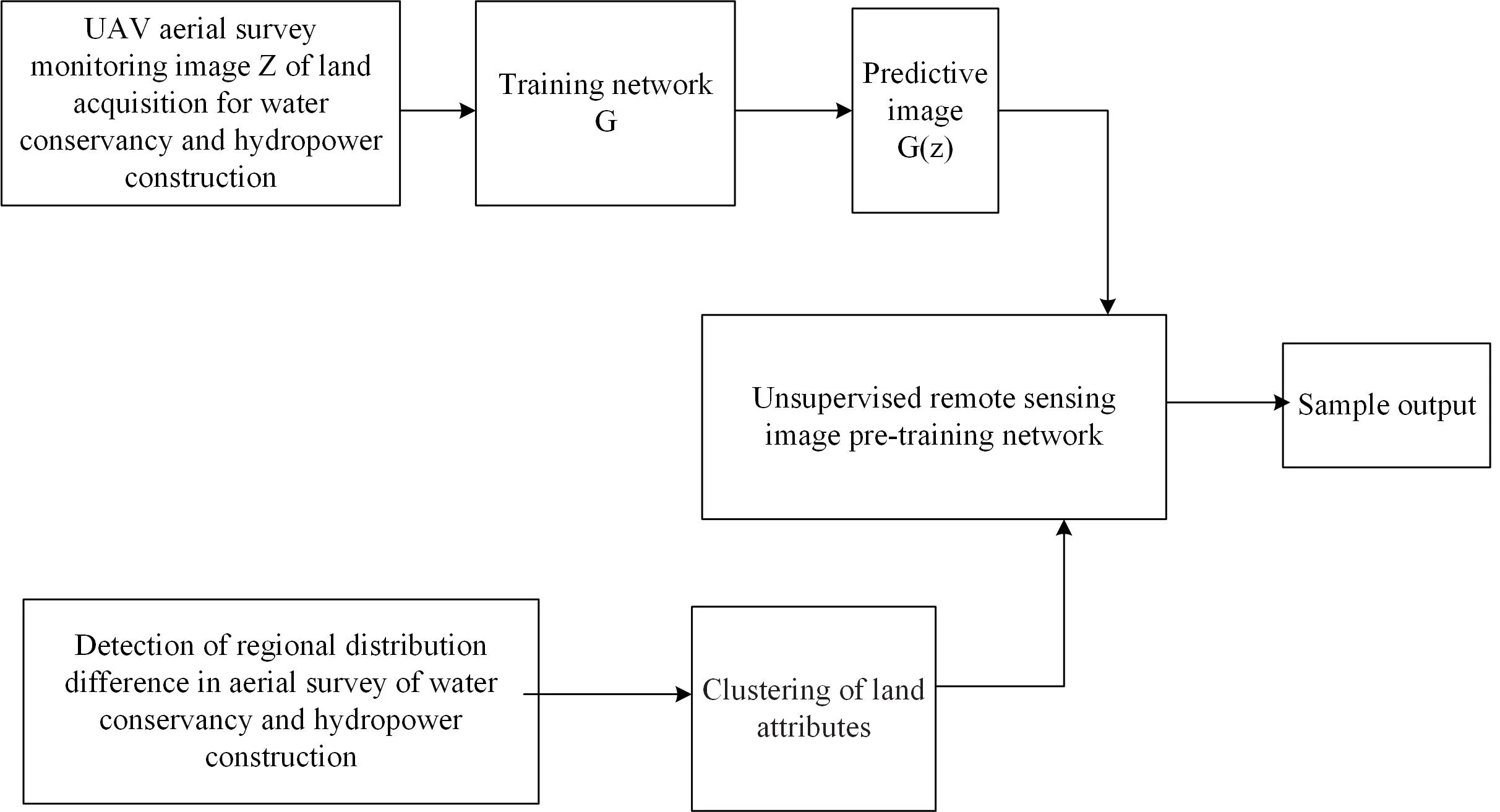
According to the detection and acquisition process of the mapping image of the water conservancy and hydropower construction land acquisition area shown in Fig. 1, extract the edge contour of the mapping remote sensing image of the water conservancy and hydropower construction land acquisition area, take the line element feature distribution point scattering remote sensing image monitored by the unmanned aerial vehicle as the data source, and use the rectangular center migration method in the cloud-free image to establish the edge contour detection model of the mapping image of the water conservancy and hydropower construction land acquisition area [7], The detailed features of the remote sensing area monitored by the UAV are obtained, and the original map is replaced. The network training process of the regional planning of land acquisition for water conservancy and hydropower construction is shown in Fig. 2 through the distribution of the edge information detected by the remote sensing mapping.
Fig. 1Mapping image detection flow chart of land acquisition area for water conservancy and hydropower construction
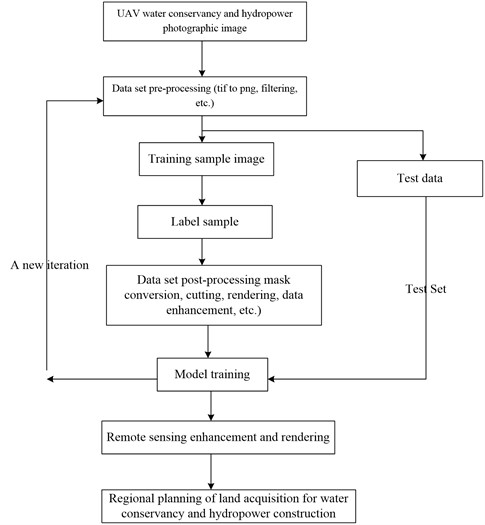
Fig. 2Network training process of land acquisition regional planning for water conservancy and hydropower construction
2.2. Remote sensing image preprocessing of land acquisition area mapping for water conservancy and hydropower construction
The remote sensing detection technology of UAV aerial survey is used to realize the remote sensing image monitoring of the planned land for land acquisition for water conservancy and hydropower construction, extract the edge contour of the remote sensing image for mapping the land acquisition area for water conservancy and hydropower construction, take the line element feature distribution point scattering remote sensing image monitored by UAV as the data source, and establish the least squares loss function of the regional mapping planning for land acquisition for water conservancy and hydropower construction through the linear target segmentation detection and processing method:
wherein, is the sample distribution of the planned land image set of the water conservancy and hydropower construction land acquisition area, is the sample error of the generated image, , , are the mask map model parameters, is the projection of the edge feature points of the remote sensing image of the water conservancy and hydropower construction land acquisition area on the , and axes, is the linear planning parameter of the coverage area. According to the clustering characteristics of the geometric attributes of dams, water body characteristics, fence facilities, power generation equipment, etc. [8]. of water conservancy and hydropower construction, the detailed information distribution sequence in the UAV monitoring remote sensing image after generating the network once every training is obtained:
wherein:
The above components respectively represent the expansion factor of pixel values after interpolation. The 3D conversion of , , is carried out in , , , the digital photogrammetric imaging of UAV is established, the multi-scale features of the input data are extracted, and the size of the mapping image S in the corresponding feature layer of the water conservancy and hydropower construction land acquisition area is , and the low-resolution feature map is mapped to the high spatial resolution space, the number of searches for land use mapping in the land acquisition area for water conservancy and hydropower construction is . According to the clustering characteristics of the geometric attributes of dams, water body characteristics, fence facilities, power generation equipment, etc. in the construction of water conservancy and hydropower projects, the diversity clustering method of the distribution pattern of geomorphic features in different terrain areas is adopted to optimize the land use mapping model [9].
3. Optimization of regional mapping for land acquisition in water conservancy and hydropower construction
3.1. Analysis of planned land use parameters in the area of land acquisition for UAV water conservancy and hydropower construction
From the perspective of visual cognition, there are similarities between the pattern segmentation of curves and the semantic segmentation of images, that is, the combination of basic units with similar features to form a locally continuous homogeneous structure Inspired by this, this paper proposes the following idea of linear object segmentation: the line elements composed of adjacent nodes are compared with the pixels in the grid model, and the linear object is organized into a sequence structure composed of line element description features [10]; On this basis, the linear target segmentation problem is transformed into the pattern classification problem of each line element, and the mapping information of different sizes is obtained by controlling the expansion rate of the map to obtain the maximum height of the spherical arc of the UAV mapping image in the water conservancy and hydropower construction land acquisition area, the large range determination threshold Delta, the constraint matrix , and the elevation sampling calculation value of the water conservancy and hydropower construction land acquisition area is:
wherein, is the intersection of the extracted topographic relief features, is the constraint solution generated by the mapping data of the water conservancy and hydropower construction land acquisition area, using the method of sectional closed constraint, and respectively represent the pixel-level fusion derivatives of the mapping line surface and the ground in the water conservancy and hydropower construction land acquisition area, extract the gradient information of the mapping elevation sampling points in the water conservancy and hydropower construction land acquisition area, and obtain the closed constraint matrix corresponding to the two target points AO and BO[11], the reference information of the spatial plane points and ground points for the mapping and distribution of land acquisition areas for water conservancy and hydropower construction is as follows:
wherein, and are the topographic relief characteristic parameters of land acquisition area for water conservancy and hydropower construction, is the elevation sampling point parameters of land acquisition area for water conservancy and hydropower construction, and the discrete point data is imported into the mapping system, and the geographic location area is detected by block, and the offset is increased [12]. The edge contour moment of UAV aerial remote sensing monitoring in land acquisition area for water conservancy and hydropower construction is expressed as follows:
wherein, and are the joint distribution coefficient of elevation sampling extracted from the gradient of water conservancy and hydropower construction land acquisition, and is the curve-type convexity-preserving feature point set of elevation sampling. According to the above analysis results of the planned land use parameters of the UAV water conservancy and hydropower construction land acquisition area, the two-point line segment is used for visual expression to realize the feature analysis and data calculation of cadastral mapping image sample information [13].
3.2. Mapping output of regional planning land for land acquisition in water conservancy and hydropower construction
After inputting the linear target to be segmented into the trained SCNN model, the model predicts the pattern category of each line element; Combine the adjacent line elements with the same pattern category to form a curve segment as the output segmentation result However, there may be a shorter curve segment in the initial segmentation result to establish a remote sensing image sensing parameter fusion model for land acquisition for water conservancy and hydropower construction. Combined with marker shape analysis, the component of the small block fusion, according to the rotation invariance of color characteristics, the regional network adjustment expression of land acquisition for water conservancy and hydropower construction is obtained as follows:
wherein, , is the remote sensing image sensing filtering parameter of the mapping of the land acquisition area for water conservancy and hydropower construction, is the local distribution dimension of the land acquisition area for water conservancy and hydropower construction, and is the convex feature point set .
The convex feature point set of the UAV sampling remote sensing image obtained from the mapping of the water conservancy and hydropower construction land acquisition area is expressed as , which is the target information thematic map sample of water conservancy and hydropower construction land acquisition areas:
wherein, is the elevation data of the corresponding pyramid level, is the maximum height parameter of the spherical arc distributed in the water conservancy and hydropower construction land acquisition area, is the elevation function of the water conservancy and hydropower construction land acquisition area after the addition of the earth center point EC, is the detection point, for , the corresponding spherical arc of the earth is drawn with the measurement value , and is used to represent the depth learning component to obtain the smoothing parameter , the collinear parameters of control points generated on both sides of each input point are obtained [14]. The length of the input line element feature sequence of the constructed SCNN model is set to 224. Two methods, sliding window and geometric transformation, are used to generate and expand sample data. As shown in Fig. 3, the sliding window method is to create a window at the starting point of the linear target and extract the curve segment inside the window as a sample; Then, slide the window according to the preset step and repeat the above operation until the termination point is included in the window. Therefore, according to the spatial distribution of different connecting lines between the two targets, high-level survey is carried out to realize the mapping of land acquisition area for water conservancy and hydropower construction based on UAV aerial survey.
4. Simulation test analysis
The GPU Shader is used to build the simulation model of land acquisition area mapping for water conservancy and hydropower construction. The R, G and B components are taken from the optical frequency output component of the spectrum of land acquisition area planning for water conservancy and hydropower construction. The initial matching points of land acquisition area mapping for water conservancy and hydropower construction are set to 6000, and the image is cut into 512 dimensions × 512, sample downsampling is 256 × 256, where the window size is set to be consistent with the length of the model input sequence, and the moving step is set to 20 lines elements. The geometric transformation method is to rotate the curve segment extracted by the sliding window to expand the sample. In the test, 4335 samples are formed for each curve segment at an interval of 15°, and 199 samples are formed for the road training data set. In order to maintain the adequacy of the overall terrain features of TIN-DDM, and take into account the requirements of the comprehensive number of sampling points, in the non-navigation TIN-DDM automatic synthesis, the sampling points with weak (strong) terrain feature expression ability should be preferentially deleted (reserved). Therefore, the sampling points with weak expression ability of topographic features, that is, the smaller value of topographic feature evaluation index, should be considered as the sampling points to be deleted first in the TIN-DDM automatic synthesis process. According to the evaluation of topographic features, the distribution of three-dimensional geographic location information for mapping is shown in Table 1.
Fig. 3Linear distribution model of land acquisition area mapping for water conservancy and hydropower construction
Table 1Distribution of three-dimensional geographic coordinate system of land acquisition area mapping for water conservancy and hydropower construction
Test point | X | Y | Z |
Test point1 | 4.960 | 3.554 | 6.365 |
Test point2 | 5.135 | 3.544 | 6.185 |
Test point3 | 4.887 | 3.455 | 6.269 |
Test point4 | 4.811 | 4.021 | 6.123 |
Test point5 | 5.108 | 3.349 | 5.911 |
Test point6 | 5.109 | 3.698 | 6.201 |
In the three-dimensional coordinate distribution space in Table 1, the 1:250000 DEM elevation data is used to carry out remote sensing monitoring of UAV aerial survey, and the DTM data of UAV aerial survey in the land acquisition area of water conservancy and hydropower construction is obtained as shown in Fig. 4.
On this basis, the regional mapping of land acquisition for water conservancy and hydropower construction is realized. The analysis and simulation results show that the TIN-DDM comprehensive idea of first deleting flat terrain sampling points and first reserving complex terrain sampling points is adopted in both algorithms, and the comprehensive effects of the two algorithms are basically the same; 2) With the increase of the comprehensive scale (when the number of sampling points is 8000 and 10000 respectively), due to the difference in the definition of the concept of “flat terrain sampling points” between the two types of algorithms, although the comprehensive effect in Area A is not very different, there is a trend that the effect of the algorithm in this paper is better than that of the algorithm in Document [5] in Area B. The main reason is that compared with area B, the gullies at the bottom of the dam in area A are widely distributed and relatively concentrated. The algorithm in literature [7] determines most of the sampling points in this area as “complex terrain sampling points”, and takes the strategy of first deleting “flat terrain sampling points” in area B to ensure the terrain characteristics of area A, which makes it difficult to maintain the terrain characteristics of area B; The micro and macro terrain type determination principle of the method in this paper realizes the effective identification of some "relatively flat sampling points" in complex terrain, and uses the terrain feature evaluation index to strictly generate the comprehensive point sequence of various “flat terrain sampling points”, and the convex hull distribution of the region on the right is shown in Fig. 5.
Fig. 4UAV monitoring topological structure of land acquisition area mapping for water conservancy and hydropower construction
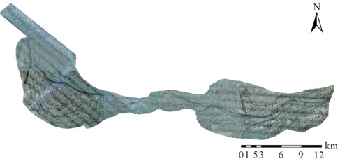
Fig. 5Convex hull distribution of land acquisition area mapping for water conservancy and hydropower construction
By the convex hull fitting results, the elevation sampling and smoothing of the land acquisition area for water conservancy and hydropower construction are carried out on both sides of the vertical bisector, as shown in Fig. 6.
By the comprehensive analysis of local geometric characteristics of the whole curve, the optimal output of regional mapping for land acquisition in water conservancy and hydropower construction is realized. The matrix method and the minimum cost path method are used to extract the centerline of the embankment data in the study area It is difficult to connect the maximum elevation grid extracted by matrix method in space. If the grid conversion vector is directly executed, a large number of broken lines will be generated. Therefore, this method still needs a lot of post-processing operations to obtain satisfactory embankment centerline data Although the dyke centerline obtained by using the minimum cost path method does not have the problem of scattered and broken lines in the matrix method, there are a lot of “burrs”, and the final regional mapping results are shown in Fig. 7.
Fig. 6Smoothing processing
Fig. 7Mapping output
The analysis of the above simulation results shows that the method in this paper can effectively realize the regional land use planning of land acquisition for water conservancy and hydropower construction, and provide data basis for the protection and management of land use planning of land acquisition for water conservancy and hydropower construction through the optimization of the regional land use planning of land acquisition for water conservancy and hydropower construction. See Table 2 for the comparison results of the correct matching rate and time of mapping, and we can learn from Table 2. The matching rate of this method is high and the time is short.
Table 2Mapping correct matching rate and time comparison
Surveying and mapping data | CAD | SUF | This method | |||
Correct matching rate | Time/s | Correct matching rate | Time/s | Correct matching rate | Time/s | |
1 | 0.600 | 12.294 | 0.884 | 12.388 | 0.962 | 4.870 |
2 | 0.612 | 12.422 | 0.906 | 12.572 | 0.962 | 5.021 |
3 | 0.598 | 13.078 | 0.878 | 12.615 | 0.959 | 4.896 |
4 | 0.616 | 16.235 | 0.861 | 12.256 | 0.956 | 4.830 |
Mean value | 0.604 | 13.685 | 0.875 | 11.973 | 0.968 | 4.132 |
5. Conclusions
This study proposes a drone based surveying and mapping technology for land acquisition areas in water conservancy and hydropower construction, and establishes a remote sensing image BIM database for land acquisition planning in water conservancy and hydropower construction. By conducting remote sensing experiments and data labeling through model validation and sample labeling methods, remote sensing image acquisition and processing of land acquisition for water conservancy and hydropower construction can be achieved. Based on the geometric properties of the dam body, water body characteristics, fence facilities, power generation equipment, and other characteristics of water conservancy and hydropower construction, a diversity clustering method was used to optimize the land use map model using the distribution pattern of geomorphic features in different terrain regions. The research results indicate that this method improves the smoothness of the mapping output of land acquisition planning in water conservancy and hydropower construction areas, with an average matching rate of 0.968 for land acquisition planning in water conservancy and hydropower construction areas and a time consumption of 4.132 s.
References
-
Yang Min, Chen Guo, Li Lianying, Huang Haoran, Miao Jing, and Yan Xiongfeng, “Segmentation of linear map objects using sequential convolutional neural network,” Acta Geodaetica et Cartographica Sinica, Vol. 52, No. 1, p. 108, Feb. 2023, https://doi.org/10.11947/j.agcs.2023.20210317
-
Zhang Hong, Wu Zhiwei, Wang Jicheng, and Gao Peichao, “Unsupervised band selection for hyperspectral image classification using the Wasserstein metric-based configuration entropy,” Acta Geodaetica et Cartographica Sinica, Vol. 50, No. 3, p. 405, Mar. 2021, https://doi.org/10.11947/j.agcs.2021.20200006
-
W. Sun and Q. Du, “Graph-regularized fast and robust principal component analysis for hyperspectral band selection,” IEEE Transactions on Geoscience and Remote Sensing, Vol. 56, No. 6, pp. 3185–3195, 2018.
-
Peichao Gao, Jicheng Wang, Hong Zhang, and Zhilin Li, “Boltzmann entropy-based unsupervised band selection for hyperspectral image classification,” IEEE Geoscience and Remote Sensing Letters, Vol. 16, No. 3, pp. 462–466, 2019.
-
Raffaele Casa et al., “Evaluation and exploitation of retrieval algorithms for estimating biophysical crop variables using Sentinel-2, Venus, and PRISMA satellite data,” Journal of Geodesy and Geoinformation Science, Vol. 3, No. 4, pp. 79–88, Dec. 2020, https://doi.org/10.11947/j.jggs.2020.0408
-
H. Huang and X. Zheng, “Hyperspectral image land cover classification algorithm based on spatial-spectral coordination embedding,” Acta Geodaetica et Cartographica Sinica, Vol. 45, No. 8, pp. 964–972, 2016.
-
C. I. Chang and S. Wang, “Constrained band selection for hyperspectral imagery,” IEEE Transactions on Geoscience and Remote Sensing, Vol. 44, No. 6, pp. 1575–1585, 2006.
-
M. Zeng, Y. Cai, and Z. Cai, “Unsupervised hyperspectral image band selection based on deep subspace clustering,” IEEE Geoscience and Remote Sensing Letters, Vol. 16, No. 12, pp. 1889–1893, 2019.
-
M. Zhang, M. Gong, and Y. Mao, “Unsupervised feature extraction in hyperspectral images based on Wasserstein generative adversarial network,” IEEE Transactions on Geoscience and Remote Sensing, Vol. 57, No. 5, pp. 2669–2688, 2019.
-
Vinhnguyen Xuan, Eppsjulien, and Baileyjames, “Information theoretic measures for clusterings comparison: variants, properties, normalization and correction for chance,” The Journal of Machine Learning Research, Vol. 11, No. 1, pp. 2837–2854, Dec. 2010, https://doi.org/10.5555/1756006.1953024
-
Wei Lifei, Yu Ming, Zhong Yanfei, Yuan Ziran, and Huang Can, “Hyperspectral image classification method based on space-spectral fusion conditional random field,” Acta Geodaetica et Cartographica Sinica, Vol. 49, No. 3, p. 343, Mar. 2020, https://doi.org/10.11947/j.agcs.2020.20190042
-
Yan Xiongfeng, Yuan Tuo, Yang Min, Kong Bo, and Liu Pengcheng, “An adaptive building simplification approach based on shape analysis and representation,” Acta Geodaetica et Cartographica Sinica, Vol. 51, No. 2, p. 269, Feb. 2022, https://doi.org/10.11947/j.agcs.2022.20210302
-
Liu Pengcheng1 and Yang Qin1, “Coastline segment model research for map generalization based on Bayesian method,” Computer Engineering and Applications, Vol. 52, No. 22, p. 174, Dec. 2016.
-
S. Minaee, Y. Boykov, and F. Porikli, “Image segmentation using deep learning: a survey,” IEEE Transactions on Pattern Analysis and Machine Intelligence, Vol. 44, No. 7, pp. 3523–3542, 2022.
About this article

The authors have not disclosed any funding.
The datasets generated during and/or analyzed during the current study are available from the corresponding author on reasonable request.
The authors declare that they have no conflict of interest.
